Trail Mountain bike Le Montet - Bocage  25 - Le Montet - Photo
 tracegps
tracegps

User

© OpenStreetMap contributors
Length
Length
23 km
Max alt
Max alt
485 m
Uphill gradient
Uphill gradient
336 m
Km-Effort
Km-Effort  
28 km
Min alt
Min alt
399 m
Downhill gradient
Downhill gradient
335 m
Boucle
Boucle
Yes
Creation date :
2014-12-10 00:00:00.0
Updated on :
2014-12-10 00:00:00.0

(0 Reviews)

Mountain bike
Mountain bike
1h30
Difficulty : Easy

Scan this QR Code to open this trail in the SityTrail application

FREE GPS app for hiking

Logo SityTrail SityTrail

IGN / Geographical institutes

Download SityTrail from the App Store Download SityTrail from Google Play

Logo SityTrail SityTrail World

The world is yours!

Download SityTrail from the App Store Download SityTrail from Google Play Download SityTrail on Huawei AppGallery

About

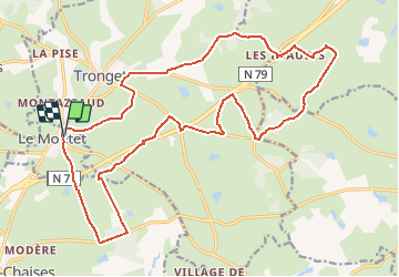
Trail Mountain bike of 23 km to be discovered at Auvergne-Rhône-Alpes, Allier, Le Montet. This trail is proposed by tracegps.

Description

Petit itinéraire sympa et très roulant au départ de Le Montet. Beaucoup de petites routes et des chemins sympas notamment par le bois de la Chassagne.

Elevation profile

Photos

Positioning

Country:
France
Region :
Auvergne-Rhône-Alpes
Department/Province :
Allier
Municipality :
Le Montet
Location:
Unknown
Start:(UTM)
504365 ; 5139478 (31T) N.

Trails nearby

Trail Mountain bike Le Montet - Bocage - Le Montet - Photo
Mountain bike
tracegps

Mountain bike

Medium
Le Montet, Auvergne-Rhône-Alpes, Allier, France
53 km | 67 km-effort
3h 30min
Yes
Trail Walking Tronget - Circuit de Tronget  - Photo
Walking
tracegps

Walking

Medium
Tronget, Auvergne-Rhône-Alpes, Allier, France
8.9 km | 10.7 km-effort
2h 15min
Yes
Trail Walking Rocles - Le sentier des noisetiers - Rocles - Photo
Walking
tracegps

Walking

Easy
Rocles, Auvergne-Rhône-Alpes, Allier, France
4.4 km | 5.6 km-effort
1h 4min
Yes


Close
My subscriptions